

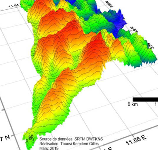


Landsat 9 was launched on Monday, Sept. 27, 2021 from Vandenberg Space Force Base in California. Landsat 9 is a partnership between NASA and the U.S. Geological Survey and Landsat 9 data is publicly available from USGS. The Landsat program, active since 1972 thanks to its various satellites, plays an essential role in the observation, surveillance, monitoring, understanding and management of natural resources necessary for the maintenance of human life. With this in mind, Landsat 9 is part of the monitoring of the United Nations 2030 Agenda of Sustainable Development Goals and the African Union Agenda 2063. Anthropogenic changes, those induced by men on nature, can be assesed by the Landsat satellite system which observes the earth’s surface in a repetitive manner.
The benefits of Landsat program for the Sustainable Development Goals are tangible. Humans occupy or otherwise use about 80 percent of the earth’s surface, including the 40 percent converted to agriculture. This land area is estimated at 150 million square kilometers, or about 30 percent of the Earth’s surface.
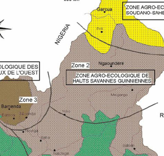
Agriculture and Food Security
Worldwide, millions of people are helped by Landsat-data-based decisions that impact food and water management. Food and farming organizations rely on the unbiased, accurate and timely information provided by Landsat satellites. The data enable people to analyze the health and vigor of crops as they mature over the growing season; the needs of specific fields for fertilizer, irrigation and rotation; planted acreage to forecast crop production and fight crop insurance fraud; how much water is used in irrigation; and the impacts of drought.
SDG 6 | SDG12 | SDG15 | SDG 2 | SDG 3
Understanding Climate Change and Carbon
Long-term weather patterns averaged over 30 years or more make up our climate. Human well-being—our infrastructure and agriculture—depend on a reliable climate. This reliability allows farmers to plant seeds in the spring with confidence that temperatures and rainfall will sustain crops in the coming months. It allows communities to build and maintain roads, buildings, and drainage systems best suited to local conditions. Earth’s climate is controlled by the amount of energy that flows through the atmosphere, oceans, and land. By adding heat-trapping gases to the atmosphere—primarily carbon dioxide—people are increasing the amount of energy in the Earth system that would otherwise escape to space. This increase in energy is changing Earth’s climate, and consequently, the weather patterns that people rely on are shifting. Changes in long-term weather patterns have wide-ranging impacts on ecosystems and peoples’ lives. Designed to observe land and coastal ecosystems, Landsat instruments provide an unparalleled space-based record of the impact of climate change on Earth’s landscapes, the growth and loss of carbon- storing.
SDG13 | SDG15 | SDG 12 | SDG 2
Disaster Management
Fire, floods, hurricanes, tornadoes, and other natural disasters can be particularly tragic and costly when critical facilities such as power plants, airports, roads, and hospitals are threatened. When a disaster strikes, remote sensing is often the only way to get a big-picture view of what is happening on the ground.
SDG 11 | SDG7 | SDG 1 | SDG 3
Managing Ecosystems & Biodiversity
Our world is made of complex networks of living things and physical elements that constantly interact and affect each other. Such networks are known as “ecosystems.” Healthy and economically important ecosystems such as temperate forests, wetlands, grasslands, coastal zones, coral reefs, and rainforests all play roles in human life.
SDG 14 | SDG 15
Energy Resources
Energy is a growing necessity for people worldwide. As the demand for energy grows, Landsat plays an important role in identifying new energy sources and mitigating the human and environmental impact of energy development. Landsat is useful in the energy sector both because of its unparalleled decades-long record of Earth’s land and because of its ability to measure infrared and visible light. With more than 40 years of imagery, decision makers can monitor the environmental impact of mining and energy generation and track ecological recovery after operations end. Landsat’s ability to measure infrared light allows farmers and decision makers to gauge the health of biofuel crops and natural vegetation near dams and mining sites. The infrared and visible measurements together help energy companies identify minerals on the surface when plants are sparse.
SDG 7 | SDG 10 | SDG 9 | SDG 15 | SDG 3 | SDG 4
Forest Management
People and economies around the world rely on forests for timber, carbon storage, flood control, biological diversity, recreation, and more. Forest managers face many challenges. In the last few years, forest fires have become more intense and more frequent; North American forests have experienced widespread infestations by pests such as the pine bark beetle; and tropical deforestation continues. Our changing climate adds complexity to government and commercial decisions about how to manage, protect, and sustain our forest resources. Landsat satellites provide key data for forest monitoring and management across the globe. Landsat gives us consistent views of the health, composition, and extent of forest ecosystems as they change over time. Curtis Woodcock, Professor, Boston University and specialist in remote sensing, has said, “I would argue that the Landsat data archive may be the most valuable environmental data record we have.” Designed, built, and launched by NASA, Landsat satellites have recorded global forest conditions every year since the 1970’s, and they have observed all U.S. forests once a season throughout those years. The U.S. Geological Survey provides this valuable data to the public at no cost. Landsat observations will continue into the future with Landsat 8.
SDG 15 | SDG 11 | SDG 13
Human Health & Environmental Justice
People have long recognized the connection between the environment and human health. Various animal and insect species from mice to mosquitoes serve as vectors that can transmit disease pathogens to people. Malaria is among the most deadly, preventable vector-borne diseases. About half of the world’s population (3.3 billion people) is at risk of contracting malaria from mosquitoes, according to the World Health Organization. Other human health problems such as cancer arise from exposure to pollutants in the environment. Finally, malnutrition can follow crop-destroying natural disasters such as drought or floods in poor regions. Landsat measurements can help decision makers pinpoint and minimize environmental health risks. With a spatial resolution of 30 meters, Landsat is well suited to mapping various components of changing landscapes, including agriculture and urbanization, that might pollute waterways. This level of detail can also show where water has accumulated in depressions to become breeding grounds for disease-carrying insect vectors. Landsat measures reflected light in both visible wavelengths and infrared wavelengths. This combination of measurements helps scientists gauge how healthy vegetation is, since growing plants generally absorb red light and reflect infrared light. Knowing the health of plants informs decision makers about cropland productivity and habitat conditions for disease-carrying insects and animals.
SDG 3 | SDG 11 | SDG 15
Supporting Urban Planning
Cities are places of light, action, complex social interactions, multi-faceted cultures, and fast-paced living. It’s no wonder cities are growing faster than rural areas. Earth experienced a milestone in the history of urban landscapes in 2008-09. More than 50 percent of the world’s human population now lives in areas of contiguous urban development. People are driving landscape-scale changes on our planet. Considering that people change the land surface, vegetation, water cycle, radiant heat, and other aspects of the landscape, the nature of this milestone has important implications for life. Using Landsat data, people can monitor urban change and also forecast patterns of change in future urban landscapes. Landsat sensors employ a spatial resolution of 30 m, an ideal scale for observing human impacts on the land. The sensors detect urban growth with visible and infrared reflectivity consistently, objectively, and dependably over time.
SDG 11 | SDG 9
Managing Water Resources
Water is essential for life. A third of Earth’s populace has unreliable access to clean water. With current population growth and environmental trends, the U.N. Environmental Program estimates that 1.8 billion people will face water scarcity by 2025. Water means survival for people and other species we rely upon to thrive, making proper stewardship of our water resources vital. Good decisions require good data. Since 1972 the Landsat series of satellites has been providing such data. Landsat-based decisions on how to manage limited water resources have impacted millions of people worldwide. From finding water for refugees in arid nations to reducing pollution in our national waterways, Landsat enables decisions that directly help people.
SDG 6 | SDG 3 | SDG 14 | SDG 11
Managing Wildland Fires
Worldwide, fire plays a critical role in maintaining healthy forests, but fire can also be damaging. Homes are destroyed and the effects on air quality can be felt for miles. Forest fires are occurring more often and with greater intensity than in years past, and Landsat plays a critical role in understanding the impact. Landsat data enables land managers and scientists to assess the severity and extent of large fires as they plan recovery efforts; to improve safety and prevent damage to life, property and natural resources; to estimate how much pollution burning releases into the air; and to monitor the post-fire recovery of burned areas. Landsat satellites have been collecting information about forest fires since the 1970s. Landsat plays an important role in assessing the impact of fires on forest ecosystems and human society. Landsat satellites document the location and extent of burned areas, how severely fires burn, and the subsequent regrowth of the land after a forest fire. All this information helps land managers better manage our forests and other natural resources in the context of fire.
SDG 15 | SDG 11 | SDG 13 | SDG 3
Reference : Landsat Science